It’s equally inspiring and discouraging to live in an area with so many ultra distance trail crushers. It seems multiple times per week, I read about local friends and icons of sport in my social feeds going some unimaginable distance at a pace that is hard to relate to. We are all on that spectrum, really. I recognize that my efforts may seem mellow to some but mind blowing to many others. Clearly the most important thing is to get out there, experience all the feels and explore one's own potential. Dragging some friends into the action is always a good call as well…more on that later.

The Timberline Trail around Mt. Hood is an iconic trail loop that usually frees from the grips of snow in early to mid July. The route loosely travels all the way around Mt Hood at the 6,000’ level which is also the line at which thick subalpine forests turn to rocky slopes and meadows… thus the name. On this roughly 43 mi loop, you bob above and below the treeline the entire time as you travel on mostly buffed trails. The highpoint is Gnarl Ridge at 11 mi in and 7,331’. The low point is the exit trailhead at just under 2.500’. The other benefit of this route is that the last 20 mi from Gnarl Ridge to the TH is mostly downhill. Sure beats the alternative!


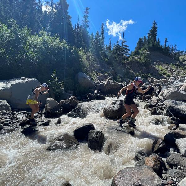
The raw stats also include a half dozen river crossings that have real consequences: both accessing them on steep, loose slopes and crossing them, especially when rain or snow runoff is surging. The big crossings include White River at 2.25 mi, Clark Creek at 6 mi, Newton Creek at 7.5 mi, and the Eliot crossing at just under 14 mi. (The Eliot crossing posed increased risk with the soft, steep entry/exit slopes. Keep an eye out for a rope on the far side of the creek when climbing out and be sure to go one at a time to avoid raining loose rock down on your crew below.) Challenging crossings persist if you were to continue along the trail back to Timberline Lodge, but we’ll save that beta for another report.

These crossings often result in SAR team rescues and even death for trail users that lose their footing. While it's comfortable for some, these crossings understandably turn many people back in the direction they came.
This is a great trail regardless of weather conditions, as you are never in exposed alpine terrain for too long and it's pretty easy to stay on the trail. I highly recommend using a GPS device to track your route given the vast network of trails on Mt Hood that can easily get you off track. My first time around this loop, we added 3 miles by taking a wrong turn. That was a most unwelcome realization at the time and for the remainder of that day. On that note, here is a link to a GPX file of the route.
While the 43 mi loop is an excellent accomplishment over a period of three to four days with a backpack or in a single push, there are many fun variations as well. A route I’ve come to love is the 50K route from Timberline Lodge to Ramona Falls Trailhead, heading counter clockwise. It requires a vehicle drop at Ramona Falls which is pretty easy to set up if you are driving up HWY 26 from Portland. Simply duck off the hwy at Lolo Pass Rd in Zig Zag and ditch a rig at the TH as you head to the lodge.

I’ve always started pre dawn to minimize time in the heat of the day while also getting to enjoy some early morning stars and a stunning sunrise. This starts off with a 2.25 mi descent into White River. While the trail is sandy and forgiving, it's also a great place to blow out your quads before the real work begins. Be realistic about your downhill durability and consider a more conservative start here with a slower, less abusive pace. The river crossing is made spicier if done under the cover of darkness. While I love this action, it can be quite intimidating.

From there, you grind uphill into the Mt Hood Meadows Resort. It’s fun to see this terrain sans snow for skiers that typically shred the ski area in the winter. Travel is cruisy and we were treated to some stellar light as the sunrise came up over the horizon in front of us.


Eventually, you drop into Heather Canyon. The trail includes some more exposure here, but it’s quite manageable and well maintained. There is a crossing above a waterfall at the base of Heather Canyon before a larger crossing of the Clark drainage a bit further on. This one presented some challenges for our shorter legged crew members. From there, you grind up a bit to enter the Newton Creek Drainage over Pea Gravel Ridge.
Again, take your time across Newton Creek. Accessing the creek took a short bit of route finding (head upriver a bit) and the water can pulse through there depending on conditions. From Newton Creek, you begin the robust climb up to the route high point of Gnarl Ridge. It helps to have a talker in the group to take your mind off the endless climb. Views on the upper ridge are incredible as you look back toward Mt Hood Meadows, across Heather Canyon. Views of Wy’East Face, Newton Clark Headwall, Black Spider and Cooper Spur are all on offer from this perch.

Access to water remains plentiful as you contour around the mountain toward Cooper Spur, Tilly Jane and Cloud Cap Inn. The terrain is quite rocky and not as runnable, but the cruisy descent is most welcome following the Gnarl grind.
As you approach Cooper Spur Ridge and the Eliot Glacier drainage, you can either stay on the beaten path or attain the ridge and walk down it toward the Eliot crossing. The travel on the ridge is less buffed out but the views into the Eliot are some of the best you can see all day. From this point, you drop quickly into the canyon via switchbacks. Accessing the river involves loose, steep walls. The river is a bit choked. This results in some good crossing options, but the water is pumping and steeper than the other crossings. On the other side, the exit terrain is loose and steep as well. I recommend sending one person up the exit slope at a time to avoid kicking rocks down on the people below. Also, keep an eye out for a rope on this exit slope.
From here, you wind around the mountain, with a couple ups and downs. At mile 20, you enter Elk Cove. This is a lush zone with more wetlands and a babbling brook running through it. It’s a great place to take a break and refill water. Bugs were rather pesky so we didn’t stay as long as our legs might have liked. After a couple short uphill ramps, the trail wraps around McNeil Point and begins a long descent to the Sandy River. The trail is awkwardly steep in many sections, but clear of blow down debris experienced in 2021 after the significant windstorms. This is a great place to pick up time and enjoy the shade cover of the trees. You travel through some gorgeous forests on your way to the Muddy Fork crossing. This crossing has a large log spanning a wide but not super intimidating creek. From here the trail is easy traveling. You have one last crossing of the Sandy River. It has always had a large log or two to traverse. On wobbly legs it's smart to be deliberate and keep the eye on that post trip pizza/ice cream/beer prize!


Whether you are seeking a mountain run or hike to push you into the ultra distances, or simply want to experience more of what Mt. Hood has to offer, this is a great stretch of trail around our local volcano. I hope to travel parts or all of it annually for many decades to come. Feel free to reach out with any questions. I am always amazed at the new beta I gather on each trip around.
Trip Stats:
-
Start Time: 4:30am
-
Finish Time: 4:09pm
-
Total Time: 11hr 41min
-
Distance: 31mi
-
Elevation Gain: 5,994’
-
Elevation Loss: 9,377’
-
No Permit required at either lot as of August 2022. Permit requirements expected in coming years.
-
Critical gear:
-
Water filter. We had a Sawyer water filter but failed to test before embarking on our route. It was totally clogged and we were unable to flush it on our trip. This is apparently a known issue with Sawyer filters. Good reminder to check, double check, before embarking on a mission like this.
-
Trekking poles,
-
Perhaps 20-50’ of thin rope or cordelette for water crossing and accessing/exiting creeks on steep slopes
-
-
Water availability: Water is readily available throughout the route. While we did not use a filter, with no ill effects 5 days after the mission, it is not recommended.
-
Bugs: They can be nasty. We experienced biting flies but no mosquitoes in late August.